Holistic 3D Dust Monitoring System
The Integro™ LIDAR Network is a turnkey solution that effectively and efficiently monitors on-site dust levels and displays data in near-real time, providing accurate feedback to enable dust mitigation strategies including suppression systems. It is an indispensable operational tool for companies looking to increase efficiency and enhance workplace safety while ensuring compliance with environmental regulations.
- Integro™ LIDAR Network is a turnkey solution that effectively and efficiently monitors on-site dust levels and displays data in near-real time, providing accurate feedback to enable dust mitigation strategies including suppression systems.
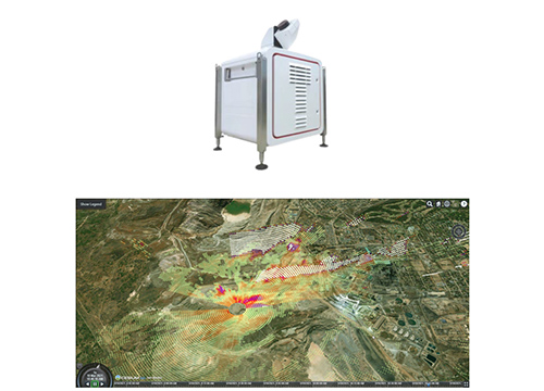
- A Light Detection and Ranging (LIDAR) Leosphere Windcube® continuously scans the required area & measures dust concentration & radial wind speed/wind direction. Windcube® can be configured for radial scan or vertical scan
- Captures 10,000-50,000 individual data points of dust dispersion per scan every 5-10 mins.
- Three or more fixed, reference-quality dust & meteorological stations. LIDAR technology works in harmony with the fixed stations, using their regulatory dust concentration measurements to correlate its scanned data. Holistic 3D Dust Monitoring System
- Acoem Airodis™ software can capture, analyse & correlate data every 5-10 mins.
- Acoem Cloud, a web browser-based, fully-interactive interface gives users a high-resolution Google Earth-like 3D viewing experience for live and historical site data.
- LIDAR measures dust emission sources, movement, and trajectories over an entire scanned area ranging from a few hundred metres up to 12 km (24 km scan diameter).
- Stockpiles studies
- Train / ship loading activity studies
- Conveyor stations
- Municipal waste facilities
- Remediation sites
- Dust source studies
- Mining area studies
- Settling & evaporation ponds studies